REAL GEOGRAPHICAL LOCATION
|
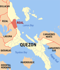
Real Quezon is composed of 17 Barangays, the 7th Barangay is Maragondon where the R.E.A.P. Camp is located. The municipality of Real is part of the REINA (Real, Infanta, General Nakar) of the Province of Quezon. It is bounded on the north by the municipality of General Nakar and Infanta, on the south by the municipalities of Mauban and Sampaloc, on the east by the Lamon Bay, and on the west by the Provinces of Rizal and Laguna. Geographically, it lies at coordinates 14° 60' 00" North Latitude and 121° 36' 00" East Longitude.
A well-paved concrete road connects the Municipality of Real with northeast Manila at a distance of approximately 145 kilometers, while Lucena City, the provincial capital is 133 km away. By water transportation, Polillo Island can be reached within 2.5 hours by motor launch, and almost the same number of hours to reach the town of Mauban. |

|
MEMBERSHIP & AFFILIATION